|
|
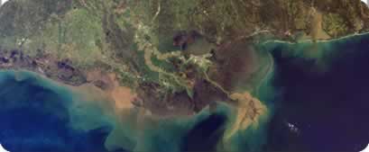
Image courtesy Liam Gumley, Space Science and Engineering Center, University of Wisconsin-Madison and the MODIS science team. The Mississippi River carries roughly 550 million metric tonnes (500 million tons) of sediment into the Gulf of Mexico each year. This true-color image, acquired from the Moderate Resolution Imaging Spectroradiometer (MODIS) aboard NASA’s Terra satellite via direct broadcast on March 5, 2001 at 10:55 AM local time, shows the murky brown water of the Mississippi mixing with the dark blue water of the Gulf two days after a rainstorm. The river brings enough sediment from its 3,250,000 square km (1,250,000 square mi) basin to extend the coast of Louisiana 91 m (300 ft) each year. customRS in Action
This project is supported by a NASA Stennis Space Center |
|